Category:Old rail transport maps of the United Kingdom
Jump to navigation
Jump to search
Subcategories
This category has the following 2 subcategories, out of 2 total.
Media in category "Old rail transport maps of the United Kingdom"
The following 56 files are in this category, out of 56 total.
-
 0. G&I map ok.jpg 1,200 × 906; 195 KB
-
 1836 map of Grainger's railway termini proposal for Newcastle.jpeg 1,280 × 1,584; 1.04 MB
-
.jpg/120px-The_Harmsworth_atlas_and_Gazetter_1908_(135848441).jpg) The Harmsworth atlas and Gazetter 1908 (135848441).jpg 12,660 × 9,590; 106.95 MB
The Harmsworth atlas and Gazetter 1908 (135848441).jpg 12,660 × 9,590; 106.95 MB
-
.jpg/120px-The_Harmsworth_atlas_and_Gazetter_1908_(135848461).jpg) The Harmsworth atlas and Gazetter 1908 (135848461).jpg 12,606 × 9,590; 110.46 MB
The Harmsworth atlas and Gazetter 1908 (135848461).jpg 12,606 × 9,590; 110.46 MB
-
%27_(11220736555).jpg/92px-thumbnail.jpg)
-
.jpg/120px-72_of_%27The_Official_Guide_to_the_Midland_Railway_..._Abridged_and_popular_edition._Illustrated%27_(11236353676).jpg)
-
.jpg/120px-thumbnail.jpg)
-
 Cheffins's Map of English & Scotch Railways, 1850.jpg 1,322 × 1,285; 381 KB
-
 Cheshire Lines map 1899.jpg 1,951 × 1,508; 634 KB
-
 Map of Barry Railway 1920.jpg 2,191 × 3,642; 1.2 MB
-
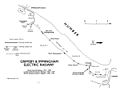
 Map of Belfast & County Down Railway 1926.jpg 896 × 1,314; 307 KB
-
 Map of Caledonian Railway 1920.jpg 1,297 × 1,887; 577 KB
-
 Map of Cambrian Railways 1920.jpg 2,072 × 2,976; 994 KB
-
 Map of Cheshire Lines Committee 1926.jpg 1,341 × 875; 338 KB
-
 Map of Cockermouth, Keswick and Penrith Railway 1920.jpg 3,096 × 2,472; 820 KB
-
 Map of Furness Railway 1920.jpg 2,095 × 3,202; 983 KB
-
 Map of Glasgow and South Western Railway 1920.jpg 2,336 × 2,656; 845 KB
-
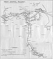 Map of Great Central Railway 1920.jpg 1,934 × 2,150; 1.89 MB
-
 Map of Great Eastern Railway 1920.jpg 2,399 × 3,746; 1.8 MB
-
 Map of Great North of Scotland Railway 1920.jpg 3,312 × 2,152; 1.14 MB
-
_1926.jpg/98px-Map_of_Great_Northern_Railway_(Ireland)_1926.jpg) Map of Great Northern Railway (Ireland) 1926.jpg 911 × 1,116; 263 KB
Map of Great Northern Railway (Ireland) 1926.jpg 911 × 1,116; 263 KB
-
 Map of Great Northern Railway 1920.jpg 1,231 × 1,820; 615 KB
-
 Map of Great Western Railway 1920.jpg 2,783 × 1,785; 2.68 MB
-
 Map of Great Western Railway 1926.jpg 2,440 × 1,869; 2.3 MB
-
 Map of Highland Railway 1920.jpg 2,097 × 3,271; 1,024 KB
-
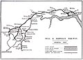 Map of Hull and Barnsley Railway 1920.jpg 2,880 × 2,096; 463 KB
-
 Map of Inland Navigation I.jpg 2,465 × 1,980; 1.42 MB
-
 Map of Inland Navigation II.jpg 2,430 × 1,980; 1.33 MB
-
 Map of Inland Navigation III.jpg 2,430 × 1,980; 1.2 MB
-
 Map of Inland Navigation IV.jpg 2,465 × 1,980; 1.48 MB
-
 Map of Inland Navigation V.jpg 2,392 × 1,980; 1.28 MB
-
 Map of Inland Navigation VI.jpg 2,428 × 1,980; 1.38 MB
-
 Map of Isle of Wight Central Railway 1920.jpg 3,160 × 2,224; 914 KB
-
 Map of Lancashire and Yorkshire Railway 1920.jpg 3,704 × 2,392; 1.18 MB
-
 Map of London and North Western Railway 1920.jpg 1,231 × 1,801; 654 KB
-
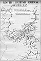
 Map of London and South Western Railway 1920.jpg 1,946 × 1,316; 610 KB
-
 Map of London, Brighton and South Coast Railway 1920.jpg 3,464 × 2,240; 686 KB
-
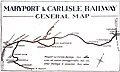 Map of Maryport and Carlisle Railway 1920.jpg 3,160 × 1,888; 399 KB
-
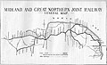 Map of Midland & Great Northern Joint Railway 1926.jpg 1,422 × 865; 261 KB
-
 Map of Midland and South Western Junction Railway 1920.jpg 2,239 × 3,305; 751 KB
-
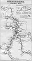 Map of Midland Railway 1920.jpg 1,287 × 2,387; 751 KB
-
 Map of North British Railway 1920.jpg 1,295 × 1,936; 648 KB
-
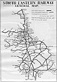 Map of North Eastern Railway 1920.jpg 1,448 × 2,076; 848 KB
-
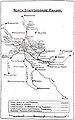 Map of North Staffordshire Railway 1920.jpg 2,111 × 3,369; 1,020 KB
-
 Map of Northern Counties Committee 1926.jpg 2,960 × 1,720; 471 KB
-
 Map of Somerset & Dorset Joint Railway 1926.jpg 851 × 1,261; 309 KB
-
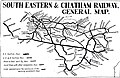 Map of South Eastern and Chatham Railway 1920.jpg 3,592 × 2,320; 1.3 MB
-
 Map of Southern Railway 1926.jpg 2,674 × 1,703; 2.58 MB
-
 Map of Stratford-upon-Avon and Midland Junction Railway 1920.jpg 3,472 × 2,256; 663 KB
-
 Map of Taff Vale Railway 1920.jpg 2,145 × 3,159; 1,011 KB
-
.jpg/50px-thumbnail.jpg)
-
.jpg/51px-thumbnail.jpg)
-
.jpg/98px-thumbnail.jpg)
-
.jpg/96px-thumbnail.jpg)
-
 Map of Wirral Railway 1920.jpg 3,120 × 2,152; 607 KB
-
 Roell-1912 Karte der Britischen und Irischen Eisenbahnen.jpg 3,456 × 4,734; 1.77 MB


.jpg)
.jpg)
%27_(11220736555).jpg)
.jpg)
.jpg)


_1926.jpg)


.jpg)
.jpg)
.jpg)
.jpg)

