Category:Rail transport maps of South Yorkshire
Jump to navigation
Jump to search
Subcategories
This category has only the following subcategory.
Media in category "Rail transport maps of South Yorkshire"
The following 35 files are in this category, out of 35 total.
-
 Ashton-under-Lyne.png 1,540 × 586; 68 KB
-
 Bawtry - haxey.png 1,075 × 688; 61 KB
-
 Dearne Valley line.png 4,869 × 6,762; 14.01 MB
-
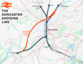 Doncaster Avoiding Line.png 4,733 × 3,638; 6.35 MB
-
 Doncaster Sheffield Airport Schematic with new station proposed.png 2,700 × 1,800; 661 KB
-
 Doncaster–Lincoln line.png 1,733 × 1,390; 1.56 MB
-
 Hallam Line.png 4,594 × 5,079; 11.01 MB
-
 Hatfield Peat Works.jpg 1,002 × 786; 107 KB
-
 Hope Valley Line map.png 1,229 × 584; 791 KB
-
 Hope Valley Line.png 3,052 × 1,886; 4.09 MB
-
 Hope Valley Line.svg 1,152 × 547; 1.86 MB
-
 HS3-2017-map.png 2,157 × 1,440; 3.51 MB
-
 Knottingley - Shaftholme Line.png 3,796 × 3,434; 4.17 MB
-
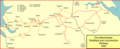 MS&L Railway in 1896.png 1,534 × 620; 93 KB
-
 Nmrmap.jpg 400 × 1,183; 72 KB
-
.jpg/40px-North_Midland_Railway_(connectivity_map%2C_2008).jpg) North Midland Railway (connectivity map, 2008).jpg 400 × 1,183; 73 KB
North Midland Railway (connectivity map, 2008).jpg 400 × 1,183; 73 KB
-
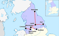 Northern Powerhouse rail.png 2,000 × 1,250; 512 KB
-
 Penistone Line.png 2,198 × 1,956; 3.31 MB
-
 Sheff dist 1970.png 1,522 × 854; 81 KB
-
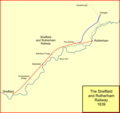 Sheff&roth1839.png 1,019 × 956; 42 KB
-
 Sheff&roth1840.png 1,019 × 956; 48 KB
-
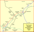 Sheff&roth1870.png 1,019 × 956; 80 KB
-
 Sheff-Dist-Rly.png 1,068 × 1,125; 93 KB
-
 Sheffield and Rotherham Railway Map 1840.jpg 1,042 × 644; 119 KB
-
.svg/120px-Sheffield_Area_1950_(rev).svg.png) Sheffield Area 1950 (rev).svg 1,800 × 1,550; 147 KB
Sheffield Area 1950 (rev).svg 1,800 × 1,550; 147 KB
-
 Sheffield Area 1950 antialias.png 2,048 × 1,760; 242 KB
-
 Sheffield Area 1950.png 1,463 × 1,241; 46 KB
-
 Sheffield Area 1950.svg 512 × 440; 18 KB
-
 Sheffield Area 2000.png 1,258 × 1,241; 28 KB
-
 Sheffield–Lincoln line.png 2,977 × 2,159; 4.28 MB
-
 South Humberside Main Line.png 6,980 × 3,780; 7.24 MB
-
 Swinton–Doncaster line.png 5,536 × 3,399; 6.17 MB
-
 Thorne Moors Peat Works.jpg 683 × 721; 76 KB
-
 Wakefield line.png 4,348 × 4,784; 10.12 MB
-
 Woodhead line.png 2,994 × 1,739; 4.07 MB


.svg)


.jpg)