File:Deutschland Autobahnen.svg

Original file (SVG file, nominally 1,073 × 1,272 pixels, file size: 467 KB)
Captions
Captions
Summary[edit]
| DescriptionDeutschland Autobahnen.svg |
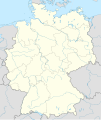
Deutsch: Karte der Autobahnen in Deutschland, Alternativkarte zu file:Germany location map.svg
|
||
| Date | |||
| Source | Own work | ||
| Author | NordNordWest | ||
| Permission (Reusing this file) |
This file is licensed under the Creative Commons Attribution-Share Alike 3.0 Germany license.
 This file is licensed under the Creative Commons Attribution-Share Alike 3.0 Unported license.
|
||
| Other versions |
Bundesrepublik Deutschland (vor 1990 nur West-Deutschland):
Deutsche Demokratische Republik (mit BRD im Ausschnitt):
Ostdeutschland (vor 1990 Deutsche Demokratische Republik):
Deutschland zwischen Mai 1945 und Oktober 1949:
Thematisch:
Deutsches Reich (1918–1945) (best used with this template (de)):
|
||
| SVG development InfoField | This map was created with an unknown SVG tool.
|
File history
Click on a date/time to view the file as it appeared at that time.
| Date/Time | Thumbnail | Dimensions | User | Comment | |
|---|---|---|---|---|---|
| current | 13:19, 14 December 2023 |  | 1,073 × 1,272 (467 KB) | NordNordWest (talk | contribs) | upd |
| 16:23, 18 July 2023 | 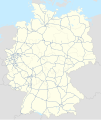 | 1,073 × 1,272 (467 KB) | NordNordWest (talk | contribs) | upd | |
| 17:59, 1 February 2023 |  | 1,073 × 1,272 (466 KB) | NordNordWest (talk | contribs) | upd | |
| 14:40, 18 November 2019 |  | 1,073 × 1,272 (465 KB) | NordNordWest (talk | contribs) | upd | |
| 17:36, 27 September 2019 |  | 1,073 × 1,272 (465 KB) | NordNordWest (talk | contribs) | upd | |
| 18:08, 5 August 2019 |  | 1,073 × 1,272 (465 KB) | NordNordWest (talk | contribs) | upd | |
| 07:02, 14 January 2019 |  | 1,073 × 1,272 (467 KB) | NJ Giggie (talk | contribs) | upd: A33 Teilstück freigegeben | |
| 18:26, 23 December 2018 |  | 1,073 × 1,272 (466 KB) | NordNordWest (talk | contribs) | upd | |
| 11:22, 4 September 2018 |  | 1,073 × 1,272 (466 KB) | NJ Giggie (talk | contribs) | corr: Autobahnenden der A61 gehen über die Kreuze Wanlo und Jackerath jeweils hinaus. Wiederherstellung des korrigierten Verlaufs der A448. | |
| 09:50, 2 September 2018 |  | 1,073 × 1,272 (465 KB) | NordNordWest (talk | contribs) | upd |
You cannot overwrite this file.
File usage on Commons
The following 73 pages use this file:
- User:Chumwa/OgreBot/Potential transport maps/2018 April 1-10
- User:Chumwa/OgreBot/Potential transport maps/2018 April 11-20
- User:Chumwa/OgreBot/Potential transport maps/2018 August 21-31
- User:Chumwa/OgreBot/Potential transport maps/2018 December 21-31
- User:Chumwa/OgreBot/Potential transport maps/2018 January 11-20
- User:Chumwa/OgreBot/Potential transport maps/2018 January 21-31
- User:Chumwa/OgreBot/Potential transport maps/2018 June 21-30
- User:Chumwa/OgreBot/Potential transport maps/2018 March 1-10
- User:Chumwa/OgreBot/Potential transport maps/2018 September 1-10
- User:Chumwa/OgreBot/Potential transport maps/2019 August 1-10
- User:Chumwa/OgreBot/Potential transport maps/2019 January 11-20
- User:Chumwa/OgreBot/Potential transport maps/2019 November 11-20
- User:Chumwa/OgreBot/Potential transport maps/2019 September 21-30
- User:Chumwa/OgreBot/Transport Maps/2018 April 1-10
- User:Chumwa/OgreBot/Transport Maps/2018 April 11-20
- User:Chumwa/OgreBot/Transport Maps/2018 August 21-31
- User:Chumwa/OgreBot/Transport Maps/2018 December 21-31
- User:Chumwa/OgreBot/Transport Maps/2018 January 11-20
- User:Chumwa/OgreBot/Transport Maps/2018 January 21-31
- User:Chumwa/OgreBot/Transport Maps/2018 June 21-30
- User:Chumwa/OgreBot/Transport Maps/2018 March 1-10
- User:Chumwa/OgreBot/Transport Maps/2018 September 1-10
- User:Chumwa/OgreBot/Transport Maps/2019 August 1-10
- User:Chumwa/OgreBot/Transport Maps/2019 January 11-20
- User:Chumwa/OgreBot/Transport Maps/2019 November 11-20
- User:Chumwa/OgreBot/Transport Maps/2019 September 21-30
- User:Chumwa/OgreBot/Transport Maps/2023 December 11-20
- User:Chumwa/OgreBot/Transport Maps/2023 February 1-9
- User:Chumwa/OgreBot/Transport Maps/2023 July 11-20
- User:Chumwa/OgreBot/Travel and communication maps/2018 April 1-10
- User:Chumwa/OgreBot/Travel and communication maps/2018 April 11-20
- User:Chumwa/OgreBot/Travel and communication maps/2018 August 21-31
- User:Chumwa/OgreBot/Travel and communication maps/2018 December 21-31
- User:Chumwa/OgreBot/Travel and communication maps/2018 January 11-20
- User:Chumwa/OgreBot/Travel and communication maps/2018 January 21-31
- User:Chumwa/OgreBot/Travel and communication maps/2018 June 21-30
- User:Chumwa/OgreBot/Travel and communication maps/2018 March 1-10
- User:Chumwa/OgreBot/Travel and communication maps/2018 September 1-10
- User:Chumwa/OgreBot/Travel and communication maps/2019 August 1-10
- User:Chumwa/OgreBot/Travel and communication maps/2019 January 11-20
- User:Chumwa/OgreBot/Travel and communication maps/2019 November 11-20
- User:Chumwa/OgreBot/Travel and communication maps/2019 September 21-30
- User:Chumwa/OgreBot/Travel and communication maps/2023 December 11-20
- User:Chumwa/OgreBot/Travel and communication maps/2023 February 1-9
- User:Chumwa/OgreBot/Travel and communication maps/2023 July 11-20
- File:Deutschland Autobahnen.svg
- File:East-West-Germany-October 1949-July 1952.svg
- File:East Germany location map.svg
- File:Germany, Federal Republic of location map 23 May 1949 - 6 Oct 1949.svg
- File:Germany, Federal Republic of location map April 1952 - August 1955.svg
- File:Germany, Federal Republic of location map December 1950 - April 1952.svg
- File:Germany, Federal Republic of location map January 1957 - October 1990.svg
- File:Germany, Federal Republic of location map October 1949 - November 1950.svg
- File:Germany, Federal Republic of location map September 1955 - December 1956.svg
- File:Germany, German Democratic Republic location map January 1957 - October 1990.svg
- File:Germany, German Democratic Republic location map July 1952 - January 1957.svg
- File:Germany, German Democratic Republic location map October 1949 - July 1952.svg
- File:Germany, German Democratic Republic location map w·o FRG July 1952 - October 1990.svg
- File:Germany, German Democratic Republic location map w·o FRG October 1949 - June 1952.svg
- File:Germany, location map (SBZ perspective) 23 May 1949 - 6 Oct 1949.svg
- File:Germany2 location map.svg
- File:Germany location map.svg
- File:Germany location map 23 April 1949 - 22 May 1949.svg
- File:Germany location map 8 Jun 1947 - 22 Apr 1949.svg
- File:Germany location map April 1992 - July 1992.svg
- File:Germany location map August 1992 - June 1993.svg
- File:Germany location map July 1993 - December 2009.svg
- File:Germany location map October 1990 - March 1992.svg
- File:Germany location map labeled 8 Jun 1947 - 22 Apr 1949.svg
- File:Lage Freiberg in Deutschland.png
- File:Relief Map of Germany.png
- File:Relief Map of Germany.svg
- Template:Germany location map/other versions
File usage on other wikis
The following other wikis use this file:
- Usage on de.wikipedia.org
- Usage on es.wikipedia.org
- Usage on fi.wikipedia.org
- Usage on gl.wikipedia.org
- Usage on it.wikipedia.org
- Usage on nl.wikipedia.org
- Usage on ro.wikipedia.org
- Usage on www.wikidata.org
Metadata
This file contains additional information such as Exif metadata which may have been added by the digital camera, scanner, or software program used to create or digitize it. If the file has been modified from its original state, some details such as the timestamp may not fully reflect those of the original file. The timestamp is only as accurate as the clock in the camera, and it may be completely wrong.
| Width | 1073.381px |
|---|---|
| Height | 1271.953px |
.svg/100px-Flag_of_the_United_Kingdom_(3-5).svg.png)






_23_May_1949_-_6_Oct_1949.svg/101px-Germany%2C_location_map_(SBZ_perspective)_23_May_1949_-_6_Oct_1949.svg.png)




_location_map.svg/101px-Germany_(+districts)_location_map.svg.png)
_location_map_2013.svg/102px-Germany_(+districts_+municipalities)_location_map_2013.svg.png)


