File:Karte Simplon-Orient-Express.png
From Wikimedia Commons, the free media repository
Jump to navigation
Jump to search

Size of this preview: 800 × 569 pixels. Other resolutions: 320 × 228 pixels | 640 × 455 pixels | 1,024 × 728 pixels | 1,280 × 910 pixels | 2,286 × 1,626 pixels.
Original file (2,286 × 1,626 pixels, file size: 860 KB, MIME type: image/png)
File information
Structured data
Captions
Captions
Add a one-line explanation of what this file represents
Summary[edit]
| DescriptionKarte Simplon-Orient-Express.png |
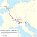
Deutsch: Zuglauf des Simplon-Orient-Express 1920 bis 1962. Landesgrenzen von 1929-1938.
English: Route of the Simplon Orient Express from 1920 to 1962. National borders as from 1929 till 1938
Français : Carte des trajets du Siplon Orient Express de 1920 à 1962. Frontiers de 1929 à 1938. |
| Date | 29 February 2012 01:46 (UTC) |
| Source |
This file was derived from: |
| Author |
|
| Other versions |
|
Licensing[edit]
This file is licensed under the Creative Commons Attribution-Share Alike 3.0 Unported license.
- You are free:
- to share – to copy, distribute and transmit the work
- to remix – to adapt the work
- Under the following conditions:
- attribution – You must give appropriate credit, provide a link to the license, and indicate if changes were made. You may do so in any reasonable manner, but not in any way that suggests the licensor endorses you or your use.
- share alike – If you remix, transform, or build upon the material, you must distribute your contributions under the same or compatible license as the original.
Original upload log[edit]
This image is a derivative work of the following images:
- File:Blank_map_of_Europe_in_1920.svg licensed with Cc-by-sa-3.0
- 2010-08-20T04:42:56Z Editor at Large 841x732 (553816 Bytes) Reverted to version as of 16:11, 23 June 2008 - error in file
- 2010-08-20T01:30:27Z Maps & Lucy 689x600 (2132 Bytes) Fixed serious error with Baltic Sea on the German border with it, fixed the border of Germany with Poland, fixed the border of Poland with the Russian SFSR, and corrected the assimulation of three southern Caucasus countries
- 2008-06-23T16:11:09Z Themightyquill 841x732 (553816 Bytes)
- 2008-06-16T15:46:25Z Themightyquill 841x732 (546594 Bytes)
- 2008-06-16T15:27:00Z Themightyquill 841x732 (543357 Bytes)
- 2008-06-16T02:32:20Z Themightyquill 841x732 (574986 Bytes) {{Information |Description={{fr|Carte vierge de l'Europe en 1920, couleurs Atelier Graphique}} {{en|Blank map of Europe in 1920 with Atelier graphique colors}} |Source=*[[:Image:Blank_map_of_Europe_-_Atelier_graphique_colors.
- File:Orient-Express_1921-1939-2.png licensed with Cc-by-sa-3.0
- 2012-02-26T20:24:44Z Pechristener 2284x1624 (1000410 Bytes) fehlende Städtenamen ergänzt / Bemerkung in der Legende / Grösse der Städtenamen
- 2012-02-26T14:56:56Z Pechristener 2285x1626 (970795 Bytes) finale Version noch nicht von [[de:User:Wahldresdner]] kontrolliert
- 2012-02-25T00:16:59Z Pechristener 2285x1626 (924048 Bytes) == {{int:filedesc}} == {{Information |Description={{en}}Route of the Orient Express Trains from 1921 to 1939. National borders as per 1929-1938 (not yet finisched) {{de}}Karte des Orient Express Züge von 1921 bis 1939. Lande
File history
Click on a date/time to view the file as it appeared at that time.
| Date/Time | Thumbnail | Dimensions | User | Comment | |
|---|---|---|---|---|---|
| current | 20:49, 8 April 2022 |  | 2,286 × 1,626 (860 KB) | Pechristener (talk | contribs) | Kurswagen von Paris über München hinzu |
| 08:21, 16 June 2019 |  | 2,286 × 1,626 (815 KB) | Pechristener (talk | contribs) | small fix in Mailand area | |
| 08:13, 16 June 2019 |  | 2,286 × 1,626 (816 KB) | Pechristener (talk | contribs) | Amsterdam und Arnhem removed | |
| 08:16, 8 June 2019 |  | 2,286 × 1,626 (824 KB) | Pechristener (talk | contribs) | == {{int:filedesc}} == {{Information |Description= {{de|1= Zuglauf des Simplon-Orient-Express 1920 bis 1962. Landesgrenzen von 1929-1938.}} {{en|1= Route of the Simplon Orient Express from 1920 to 1962. National borders as from 1929 till 1938}} {{fr|1= Carte des trajets du Siplon Orient Express de 1920 à 1962. Frontiers de 1929 à 1938.}} |Source={{Derived from|Blank_map_of_Europe_in_1920.svg|Orient-Express_1921-1939-2.png|display=50}} |Date= {{Date|2012|02|29}} 01:46 (UTC) |Author=*[[:File:Bl... |
You cannot overwrite this file.
File usage on Commons
The following 14 pages use this file:
- User:Chumwa/OgreBot/München/2019 June 1-10
- User:Chumwa/OgreBot/München/2019 June 11-20
- User:Chumwa/OgreBot/Potential transport maps/2019 June 1-10
- User:Chumwa/OgreBot/Potential transport maps/2019 June 11-20
- User:Chumwa/OgreBot/Public transport information/2019 June 1-10
- User:Chumwa/OgreBot/Public transport information/2019 June 11-20
- User:Chumwa/OgreBot/Public transport information/2022 April 1-10
- User:Chumwa/OgreBot/Transport Maps/2019 June 1-10
- User:Chumwa/OgreBot/Transport Maps/2019 June 11-20
- User:Chumwa/OgreBot/Transport Maps/2022 April 1-10
- User:Chumwa/OgreBot/Travel and communication maps/2019 June 1-10
- User:Chumwa/OgreBot/Travel and communication maps/2019 June 11-20
- File:Simplon-Express 1906-1919.png
- File:Simplonexpress 1962-2001.png
File usage on other wikis
The following other wikis use this file:
- Usage on de.wikipedia.org
Metadata
This file contains additional information such as Exif metadata which may have been added by the digital camera, scanner, or software program used to create or digitize it. If the file has been modified from its original state, some details such as the timestamp may not fully reflect those of the original file. The timestamp is only as accurate as the clock in the camera, and it may be completely wrong.
| Short title |
|
|---|---|
| Horizontal resolution | 63.48 dpc |
| Vertical resolution | 63.48 dpc |
| Software used |
Hidden categories:


