File:Miami Metro Map 2017.png
From Wikimedia Commons, the free media repository
Jump to navigation
Jump to search

Size of this preview: 717 × 600 pixels. Other resolutions: 287 × 240 pixels | 574 × 480 pixels | 918 × 768 pixels | 1,224 × 1,024 pixels | 2,449 × 2,048 pixels | 5,500 × 4,600 pixels.
Original file (5,500 × 4,600 pixels, file size: 835 KB, MIME type: image/png)
File information
Structured data
Captions
Captions
Add a one-line explanation of what this file represents
Summary[edit]
| DescriptionMiami Metro Map 2017.png |
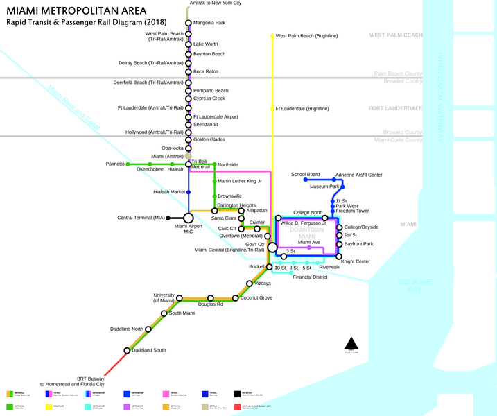
English: Schematic of rapid transit and passenger rail service in the Miami metropolitan area in 2018. Tri-Rail Downtown Miami Link and en:Brightline scheduled to be operational by the end of the first quarter of 2018. |
| Date | |
| Source | Own work |
| Author | FrickFrack |
Licensing[edit]
I, the copyright holder of this work, hereby publish it under the following license:
This file is licensed under the Creative Commons Attribution-Share Alike 4.0 International license.
- You are free:
- to share – to copy, distribute and transmit the work
- to remix – to adapt the work
- Under the following conditions:
- attribution – You must give appropriate credit, provide a link to the license, and indicate if changes were made. You may do so in any reasonable manner, but not in any way that suggests the licensor endorses you or your use.
- share alike – If you remix, transform, or build upon the material, you must distribute your contributions under the same or compatible license as the original.
File history
Click on a date/time to view the file as it appeared at that time.
| Date/Time | Thumbnail | Dimensions | User | Comment | |
|---|---|---|---|---|---|
| current | 05:17, 16 January 2018 |  | 5,500 × 4,600 (835 KB) | FrickFrack (talk | contribs) | Update for actual 2018 service |
| 11:13, 11 October 2016 |  | 5,500 × 4,600 (836 KB) | FrickFrack (talk | contribs) | Minor cleanup edits to last edition | |
| 10:52, 11 October 2016 |  | 5,500 × 4,600 (836 KB) | FrickFrack (talk | contribs) | Made recommended southwestward bend in Metrorail alignment south of Brickell and Douglas Road stations, per suggestion. Moved title to top-left to avoid clutter at the bottom of the diagram. | |
| 12:28, 3 October 2016 |  | 5,500 × 4,600 (822 KB) | FrickFrack (talk | contribs) | Updated to include recommended map changes, updated legend with regular spacing between symbols, adding additional symbols for updates. Uniform fonts for all stations. Replaced spokes at single-service station to dots uniformly. | |
| 04:50, 2 October 2016 |  | 4,962 × 4,205 (806 KB) | B137 (talk | contribs) | Add basic BRT busway line with no station detail. True BRT is increasingly being accepted as virtual light rail, and is a critical feeder to the Dadeland end of Metrorail. | |
| 02:08, 1 October 2016 |  | 4,962 × 4,205 (797 KB) | B137 (talk | contribs) | Add Amtrak services | |
| 01:55, 1 October 2016 |  | 4,962 × 4,205 (795 KB) | B137 (talk | contribs) | Add en:MIA Mover | |
| 13:10, 30 September 2016 |  | 4,962 × 4,205 (714 KB) | FrickFrack (talk | contribs) | User created page with UploadWizard |
You cannot overwrite this file.
File usage on Commons
The following 15 pages use this file:
- User:Chumwa/OgreBot/Potential transport maps/2016 October 1-10
- User:Chumwa/OgreBot/Potential transport maps/2016 October 11-20
- User:Chumwa/OgreBot/Potential transport maps/2018 January 11-20
- User:Chumwa/OgreBot/Public transport information/2016 October 1-10
- User:Chumwa/OgreBot/Public transport information/2016 October 11-20
- User:Chumwa/OgreBot/Public transport information/2018 January 11-20
- User:Chumwa/OgreBot/Transport Maps/2016 October 1-10
- User:Chumwa/OgreBot/Transport Maps/2016 October 11-20
- User:Chumwa/OgreBot/Transport Maps/2018 January 11-20
- User:Chumwa/OgreBot/Travel and communication maps/2016 October 1-10
- User:Chumwa/OgreBot/Travel and communication maps/2016 October 11-20
- User:Chumwa/OgreBot/Travel and communication maps/2018 January 11-20
- Commons:Graphic Lab/Map workshop
- Commons:Graphic Lab/Map workshop/Archive/2022
- Commons:WikiProject Aviation/recent uploads/2016 October 1
File usage on other wikis
The following other wikis use this file:
- Usage on da.wikipedia.org
- Usage on en.wikipedia.org
- Usage on en.wikivoyage.org
- Usage on eo.wikipedia.org
- Usage on fa.wikipedia.org
- Usage on id.wikipedia.org
- Usage on it.wikivoyage.org
- Usage on no.wikipedia.org
- Usage on tr.wikipedia.org
- Usage on www.wikidata.org
- Usage on zh.wikipedia.org
Metadata
This file contains additional information such as Exif metadata which may have been added by the digital camera, scanner, or software program used to create or digitize it. If the file has been modified from its original state, some details such as the timestamp may not fully reflect those of the original file. The timestamp is only as accurate as the clock in the camera, and it may be completely wrong.
| Horizontal resolution | 28.35 dpc |
|---|---|
| Vertical resolution | 28.35 dpc |