File:PLmap.png
Jump to navigation
Jump to search

Size of this preview: 800 × 380 pixels. Other resolutions: 320 × 152 pixels | 640 × 304 pixels | 1,069 × 508 pixels.
Original file (1,069 × 508 pixels, file size: 149 KB, MIME type: image/png)
Captions
Captions
Add a one-line explanation of what this file represents
Summary[edit]
| Description |
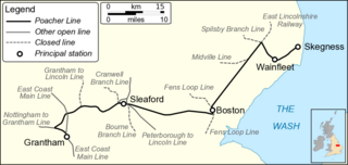
English: Map of the Poacher Line between Grantham and Skegness, Lincolnshire in the East of England. Map data taken from Open Street Maps. |
| Date | |
| Source | Own work |
| Author | Mertbiol |
Licensing[edit]
| I, the copyright holder of this work, release this work into the public domain. This applies worldwide. In some countries this may not be legally possible; if so: I grant anyone the right to use this work for any purpose, without any conditions, unless such conditions are required by law. |
File history
Click on a date/time to view the file as it appeared at that time.
| Date/Time | Thumbnail | Dimensions | User | Comment | |
|---|---|---|---|---|---|
| current | 21:39, 7 March 2010 | | 1,069 × 508 (149 KB) | Mertbiol (talk | contribs) | {{Information |Description={{en|1=Map of the Poacher Line between Grantham and Skegness, Lincolnshire in the East of England. Map data taken from Open Street Maps.}} |Source={{own}} |Author=Mertbiol |Date=2010-03=07 |Permission= |other_ |
You cannot overwrite this file.
File usage on Commons
The following page uses this file:
File usage on other wikis
The following other wikis use this file:
- Usage on azb.wikipedia.org
- Usage on en.wikipedia.org
- Usage on www.wikidata.org