File:Sheffield Area 1950.svg

Original file (SVG file, nominally 512 × 440 pixels, file size: 18 KB)
Captions
Captions
Summary[edit]
| DescriptionSheffield Area 1950.svg |
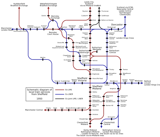
English: Schematic diagram of local railway passenger services from Sheffield in 1950. Suburban, South Yorkshire, North Derbyshire and North Nottinghamshire stations shown. |
|||||
| Date | 6 January 2007 (original upload date) | |||||
| Source | Transferred from en.wikipedia to Commons. | |||||
| Author | BaseTurnComplete at English Wikipedia | |||||
| Other versions |
File:Sheffield_Area_1950.png (PNG rendered in 2007 by the author of the SVG file) File:Sheffield_Area_1950_antialias.png (rendered from this SVG with smooth fonts but not fully accurate) |
|||||
| SVG development InfoField | This diagram uses embedded text that can be easily translated using a text editor.
|
Licensing[edit]
| Public domainPublic domainfalsefalse |
| This work has been released into the public domain by its author, BaseTurnComplete at English Wikipedia. This applies worldwide. In some countries this may not be legally possible; if so: BaseTurnComplete grants anyone the right to use this work for any purpose, without any conditions, unless such conditions are required by law.Public domainPublic domainfalsefalse |
Original upload log[edit]
| Date/Time | Dimensions | User | Comment |
|---|---|---|---|
| 2007-01-06 21:28 | 2516×2161× (48146 bytes) | BaseTurnComplete | Schematic diagram of local railway passenger services from Sheffield in 1950. Suburban, South Yorkshire, North Derbyshire and North Nottinghamshire stations shown. |
File history
Click on a date/time to view the file as it appeared at that time.
| Date/Time | Thumbnail | Dimensions | User | Comment | |
|---|---|---|---|---|---|
| current | 23:25, 17 January 2018 |  | 512 × 440 (18 KB) | JoKalliauer (talk | contribs) | increased size of file and of font |
| 09:36, 19 August 2016 |  | 2,516 × 2,161 (47 KB) | TheDJ (talk | contribs) | Set xmlns attribute to fix: Invalid SVG file: Expected <svg> tag, got svg in NS | |
| 07:26, 30 March 2016 | No thumbnail | 0 × 0 (47 KB) | FastilyClone (talk | contribs) | Transferred from enwp |
You cannot overwrite this file.
File usage on Commons
The following 9 pages use this file:
- User:Chumwa/OgreBot/Potential transport maps/2018 January 11-20
- User:Chumwa/OgreBot/Public transport information/2018 January 11-20
- User:Chumwa/OgreBot/Transport Maps/2018 January 11-20
- User:Chumwa/OgreBot/Travel and communication maps/2018 January 11-20
- User:JoKalliauer
- User:JoKalliauer/Pictures
- User:Mattbuck/Railways/2018 January 11-20
- Commons:Graphic Lab/Illustration workshop/Archive/2018
- File:Sheffield Area 1950 (rev).svg
Metadata
This file contains additional information such as Exif metadata which may have been added by the digital camera, scanner, or software program used to create or digitize it. If the file has been modified from its original state, some details such as the timestamp may not fully reflect those of the original file. The timestamp is only as accurate as the clock in the camera, and it may be completely wrong.
| Width | 100% |
|---|---|
| Height | 100% |

.svg/174px-Sheffield_Area_1950_(rev).svg.png)